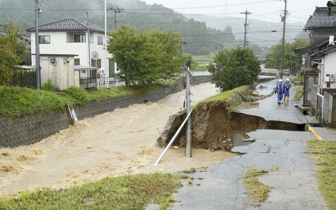
Torrential downpours engulfed large swathes of central Japan on Thursday, unleashing a cascade of natural disasters across two prefectures as the Japan Meteorological Agency sounded its most urgent alarm bells. The deluge triggered the nation's maximum alert level for multiple municipalities, forcing nearly 180,000 residents to flee their homes or seek immediate shelter as life-threatening conditions gripped Ishikawa and Toyama prefectures.
The meteorological authorities issued the Level 5 special heavy rain warning—Japan's most critical alert designation, signalling that catastrophic disaster has either already struck or is imminent—for five municipalities spanning both prefectures. The warning encompassed Himi in Toyama, and Hakui, Shika, Hodatsushimizu, and Nakanoto in Ishikawa. This escalation represents an extraordinary response to the weather system, reflecting the severity of conditions unfolding across the region and the immediate danger posed to residents.
In the twelve-hour period extending to 7:20 am local time, rainfall measurements shattered historical records at multiple observation points. Himi and Hakui both recorded more than 300 millimetres of precipitation, while Hodatsushimizu received in excess of 200 millimetres. These figures represent once-in-a-generation rainfall events for each location, overwhelming drainage systems and natural water pathways designed to handle normal precipitation patterns. Such extreme accumulation within such a compressed timeframe explained the rapid cascading of secondary hazards.
Local emergency responders on the ground documented the cascading impacts as the waters rose. A firefighting corps member in his 50s, stationed in Himi, reported to Kyodo News that a river had breached its banks, with multiple vehicles already submerged in the rising floodwaters. Such accounts underscored the speed with which flooding developed and the vulnerability of motorists caught in deteriorating conditions. Despite the scale of the disaster unfolding, prefectural authorities reported no confirmed fatalities up to the time of reporting, though the full extent of the crisis was still emerging.
Meteorological analysis indicated that the weather system would continue punishing the broader region through Friday. A frontal boundary extending from the Sea of Japan eastward through northern and eastern Japan was forecast to migrate southward, bringing additional rainfall as an unstable atmospheric column developed courtesy of a cold-air mass and a low-pressure trough aloft. This meteorological setup promised to sustain and potentially intensify precipitation across affected zones.
Projected rainfall totals for the 24-hour period through Friday noon illustrated the ongoing threat to multiple regions. Hokuriku was expected to receive up to 200 millimetres, while the Kanto-Koshin and Tokai regions faced potential accumulations of up to 150 millimetres. Niigata Prefecture, adjacent to Toyama, was simultaneously experiencing heavy rain, broadening the geographic scope of the weather emergency. Authorities across all affected prefectures maintained high alert status as these additional rainfall projections approached.
For Malaysian readers observing Japan's natural disaster response infrastructure, the rapid issuance of Level 5 warnings and coordinated evacuation directives exemplify the systematic approach developed through decades of experience managing typhoons and weather-related hazards in this seismically and meteorologically volatile island nation. The evacuation of 180,000 residents within hours demonstrates the scale and efficiency of Japan's disaster management apparatus, though it also highlights how quickly ordinary weather systems can overwhelm even well-prepared communities.
The timing of this crisis followed closely on earlier disasters that had already tested the region's capacities. Earlier in August, a comparable Level 5 warning had been issued for municipalities in Chiba Prefecture near Tokyo, triggered by similarly intense rainfall. That episode resulted in thirteen deaths and left approximately 2,500 vehicles stranded as flooding immobilised transportation networks across the prefecture. The proximity of successive Level 5 events within the same month suggested that Japan's climate patterns may be shifting toward greater frequency of extreme precipitation events, a trend with implications extending throughout Southeast Asia as global weather systems remain interconnected.
For the broader Asia-Pacific region, including Malaysia, the Japanese experience offers cautionary context regarding preparedness and response capabilities during intensifying weather events. As climate scientists document increasing atmospheric moisture availability and more volatile weather patterns globally, the scenario unfolding in central Japan—record-shattering rainfall creating cascading hazards within hours—represents the type of meteorological challenge that urban and rural communities throughout the tropics and subtropics may expect with greater regularity. Malaysia's own monsoon seasons, already capable of generating significant flooding in vulnerable areas, may face heightened risks if global precipitation patterns continue intensifying.

