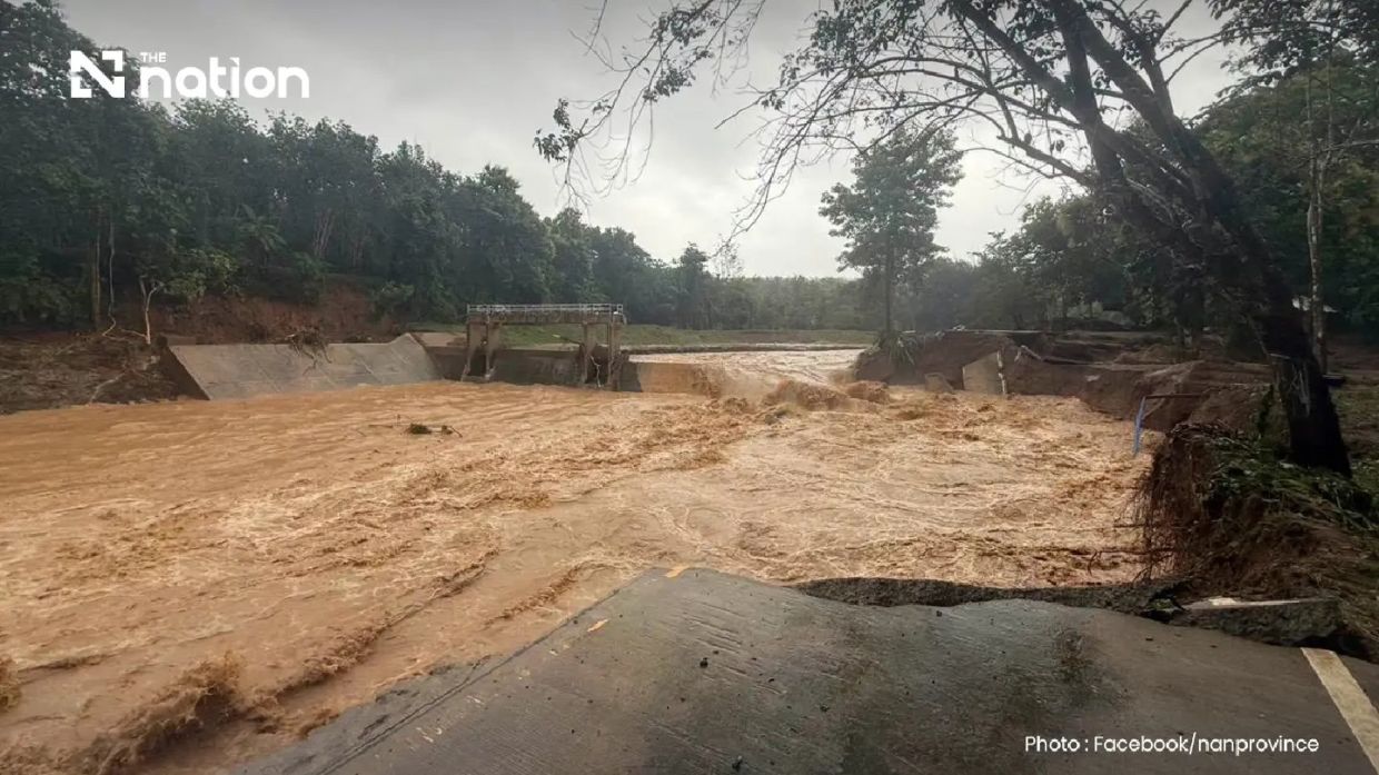
Torrential rainfall transformed much of Pua district in Thailand's Nan province into a disaster zone early Wednesday, with floodwaters consuming residential neighbourhoods and severing key transportation routes after more than 110mm of precipitation fell overnight. The catastrophic deluge, which commenced late Tuesday and persisted through the early morning hours, triggered a cascade of hydrological hazards including rapid runoff, landslides and bridge collapses that left communities isolated and authorities scrambling to coordinate rescue and relief operations.
The Doi Phu Kha National Park office documented rainfall exceeding 110mm in the Phu Kha subdistrict, a mountainous, forested region that serves as a natural water catchment. The intensity and concentration of precipitation in this headwater area meant water accumulated with alarming speed, funnelling downslope toward populated settlements below. By 6am, emergency coordinators were receiving reports of escalating inundation across multiple villages and subdistricts as water continued its destructive passage through the landscape. The sheer volume of fluid moving through usually manageable waterways turned normally benign natural channels into raging torrents incapable of containing the surplus runoff.
Residents in the hardest-hit communities faced a harrowing scramble against time as floodwaters advanced into their neighbourhoods. Families in Ban Rong and surrounding villages within Pua subdistrict had minimal opportunity to salvage possessions, rescue household appliances or secure pets before water breached their homes. The chaos of evacuation meant many occupants could only grab essentials and climb to higher floors or rooftops, abandoning years of accumulated property to the advancing water. Agricultural land throughout the affected zone suffered equally devastating losses, with crops and livestock at risk from contaminated floodwaters and the physical scouring of topsoil.
The infrastructure damage proved equally catastrophic in scope. A critical bridge spanning the route between Ban Na Lae and the entrance to Doi Phu Kha National Park, which also provides access toward Bo Kluea district, was completely washed away during the initial surge. This destruction isolated entire communities from emergency services and supply lines. Additional bridge failures were confirmed in the Fai Chao weir region, further fragmenting the transportation network. The Nan Highway District 2 office, operating under the Department of Highways, conducted rapid damage assessments and identified three major locations where vehicle traffic became impossible, restricting civilian movement and complicating official rescue efforts.
Geological instability compounded the hydrological crisis. Landslides erupted at multiple points throughout Ouan subdistrict as saturated slopes surrendered to gravitational forces, with debris flows blocking additional routes and creating secondary hazards for anyone attempting to traverse affected areas. These geological failures raised alarm among authorities that further slope failures might occur as ground saturation persisted, potentially triggering additional road blockages and threatening isolated settlements situated in vulnerable topographical positions.
Thailand's disaster management apparatus mobilised swiftly in response to the emerging emergency. The Nan Provincial Disaster Prevention and Mitigation Office activated coordination protocols and began issuing situation updates as information arrived from field teams. More significantly, the Department of Disaster Prevention and Mitigation worked in concert with telecommunications providers AIS, True and NT to disseminate an extreme alert through the Cell Broadcast system, ensuring the emergency message reached mobile phones throughout Pua district within minutes of activation.
The content of this alert conveyed unambiguous guidance to residents. The message warned of ongoing heavy precipitation with substantial risks of additional flash flooding, waterway breaches and further landslide activity. Authorities instructed residents to immediately relocate belongings to elevated positions and remove vulnerable populations—particularly elderly individuals and bedridden patients requiring assisted mobility—from ground-level locations. The alert provided explicit contact procedures for residents seeking evacuation support or requiring material assistance, directing them to communicate with subdistrict administrators, village leaders or local administrative bodies responsible for their areas. This decentralised communication structure leveraged existing community networks to facilitate rapid response rather than overwhelming centralised call centres.
Meteorological data suggested the crisis might persist or worsen before conditions stabilised. The Northern Meteorological Centre of the Thai Meteorological Department reported that Lamphun weather radar installations detected bands of light to moderate rainfall distributed across nine provinces throughout the upper North region. These rain systems were tracking south-westward, indicating the possibility that Nan and adjacent provinces might experience additional precipitation before the weather pattern shifted. The continuing threat created difficult operational challenges for rescue teams attempting to access stranded communities while simultaneously facing risks of secondary flooding if new precipitation arrived before ground saturation decreased.
For regional observers, the Nan flooding underscores the recurring vulnerability of northern Thailand's mountainous terrain to precipitation events concentrated over headwater zones. These districts depend substantially on agriculture and eco-tourism, both sectors vulnerable to infrastructure disruption and environmental degradation from extreme weather. The rapid response through Cell Broadcast systems demonstrates how Southeast Asian nations have integrated technology into disaster management, yet the incident also reveals the persistent challenge of protecting distributed rural populations when topographical features isolate communities from rapid external assistance. Authorities were working against geography itself—the same mountainous terrain that makes the region economically distinctive and scenically valuable creates hydrological conditions where concentrated rainfall transforms valleys into temporary inland seas almost instantaneously.

