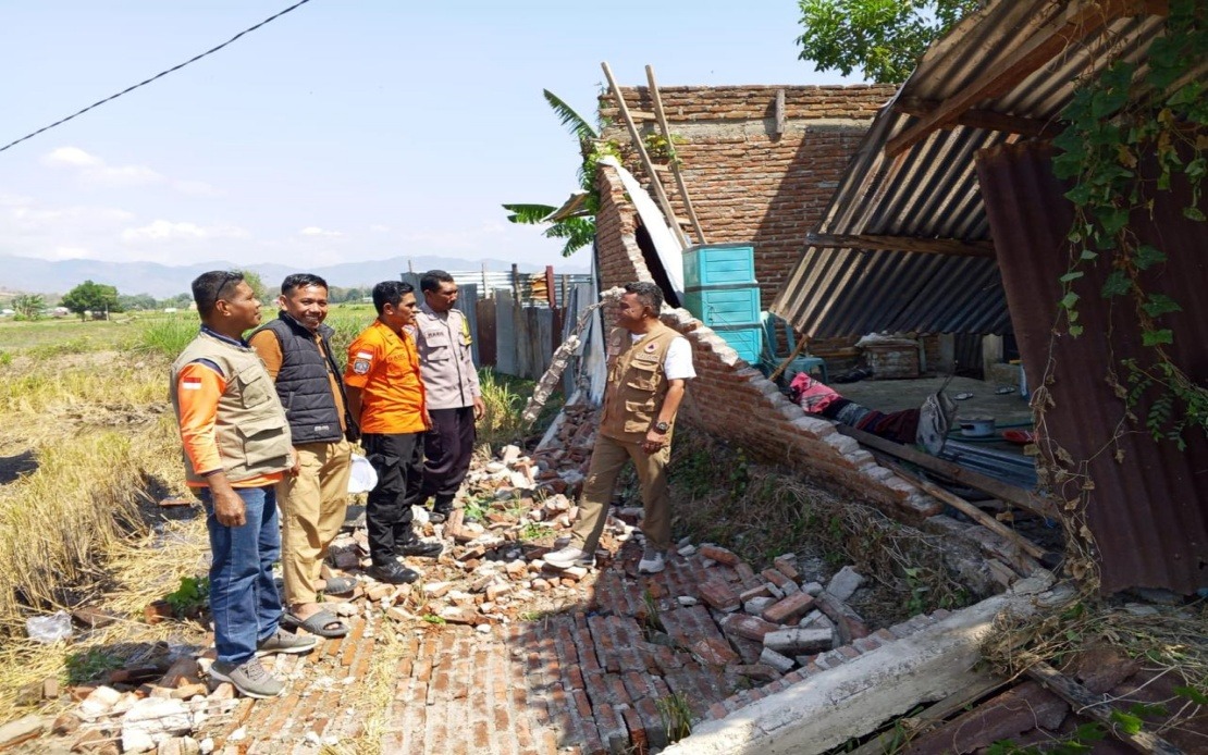
Indonesia's Flores Island in East Nusa Tenggara province experienced a devastating magnitude 7.7 earthquake in the early hours of Saturday, displacing roughly 2,000 residents as authorities and residents themselves rushed to reach safety following the powerful tremors and subsequent tsunami alert. The incident underscores the persistent seismic vulnerability facing Indonesia, which sits along the Pacific Ring of Fire and remains one of the world's most earthquake-prone regions.
According to the National Disaster Management Agency (BNPB), the earthquake struck at 4:58 am local time with its epicentre located approximately 30 kilometres from Mbay in the sea at a depth of 15 kilometres. The initial tremor was followed by what officials described as sustained seismic activity, with authorities recording 111 aftershocks in the immediate aftermath. Berton Suar Pelita Panjaitan, acting chief of the BNPB's Disaster Data, Information and Communication Centre, explained that most residents either moved to designated evacuation points or independently sought higher ground and safer locations following the strong ground motion.
The Meteorology, Climatology and Geophysics Agency (BMKG) issued a tsunami warning immediately after the main shock, but lifted the alert at 7:31 am after monitoring revealed that sea levels had stabilised without any significant additional rise. This rapid assessment proved crucial in allowing residents to return to their homes and enabling rescue operations to commence without the added complication of a major sea surge. The swift communication of the all-clear signal helped reduce panic and allowed authorities to focus resources on assessing damage and providing medical assistance.
Preliminary damage assessments conducted during the aftermath documented substantial destruction across Flores's settlements and infrastructure. Fifty-four houses were classified as severely damaged, nine sustained moderate damage, and eleven experienced minor structural harm. Beyond residential structures, the earthquake affected critical facilities including five health centres, one educational institution, three places of worship, a warehouse operated by state food logistics agency Bulog, and six government offices. Manggarai district emerged as one of the hardest-hit areas, with 29 houses severely compromised, nine moderately damaged, and nine suffering minor damage. The neighbouring East Manggarai district recorded 23 severely damaged houses, indicating that the damage concentrated heavily in western Flores.
For Malaysian readers and observers across Southeast Asia, the scale of this disaster carries particular relevance given the region's shared geological hazards and similar patterns of settlement in earthquake-prone zones. Like Malaysia and other neighbouring nations, Indonesia faces the constant challenge of balancing economic development and population growth in areas of known seismic risk. The rapid deployment of evacuation procedures and the coordination between multiple government agencies demonstrated capacity, though the ongoing assessment phase highlighted that full damage documentation remains an evolving process requiring ground-level verification and validation.
The confirmed death toll reached at least 20 persons, with six others sustaining injuries and two remaining trapped in collapsed structures as of the latest reports. These figures, however, remained subject to revision as search and rescue operations continued across affected communities. The Maumere Search and Rescue Office coordinated much of the immediate response, though the scale of the disaster required support from military, police, and local government personnel mobilised from across the province and neighbouring regions.
The earthquake's impact extended beyond physical damage to infrastructure and buildings, disrupting telecommunications services across the province. The Communication and Digital Affairs Ministry reported that approximately 200 base transceiver station (BTS) sites across 10 districts and cities in East Nusa Tenggara experienced service interruptions as of 7 am on Saturday. These disruptions represented roughly 16.35 per cent of all BTS sites operating in the affected areas, severely hampering emergency communications and coordination efforts when such connectivity was most critical. The ministry's Digital Infrastructure director-general Wayan Toni Supriyanto stated that his office was actively coordinating with commercial mobile operators to restore full coverage as quickly as possible.
The telecommunications outages presented a secondary challenge to disaster response operations, as emergency responders rely heavily on mobile networks to coordinate rescue efforts, share real-time information with field teams, and maintain contact with affected residents seeking assistance. The restoration of these services became a parallel priority alongside medical response and structural assessment. The involvement of multiple mobile operators in the recovery effort highlighted how modern infrastructure failures can compound the challenges facing disaster management teams, particularly in remote or less densely populated areas already struggling with limited medical and technical resources.
Indonesian officials emphasised that comprehensive impact assessments remained ongoing, with regional disaster management agencies, military and police units, and local government bodies continuing to gather and verify data about casualties, structural damage, and the specific needs of displaced populations. The methodical approach to damage assessment, while necessary for accurate resource allocation and relief distribution, meant that initial figures would likely change as teams completed detailed surveys of affected communities. This iterative assessment process is standard in Indonesian disaster response but also underscores the challenge of providing timely and accurate information to the public during the critical early phases of a major disaster.
The earthquake's occurrence during weekend hours, when many residents were still indoors, potentially affected casualty patterns and response times. The 4:58 am timing meant most people were asleep when the tremor struck, giving them little time to respond consciously to earthquake warnings, though the intensity and duration of the shaking likely triggered survival instincts and immediate movement toward open spaces. Saturday morning, when the assessment was being conducted, provided some advantage for search and rescue teams, as daylight made it easier to locate damaged structures and identify survivors requiring immediate extraction.
For regional observers, the Flores earthquake serves as a reminder of Indonesia's ongoing vulnerability to major seismic events and the importance of maintaining robust early warning systems, adequately resourced emergency response capacity, and resilient communication infrastructure. The rapid mobilisation of resources and the coordination between different government agencies demonstrated institutional competence, though the scale of disruption revealed areas where further investment in disaster preparedness could yield significant benefits. As Indonesia continues to develop economically, ensuring that earthquake-prone regions maintain adequate evacuation routes, emergency shelter capacity, and functioning communication systems remains critical to minimising casualties and enabling rapid recovery.

