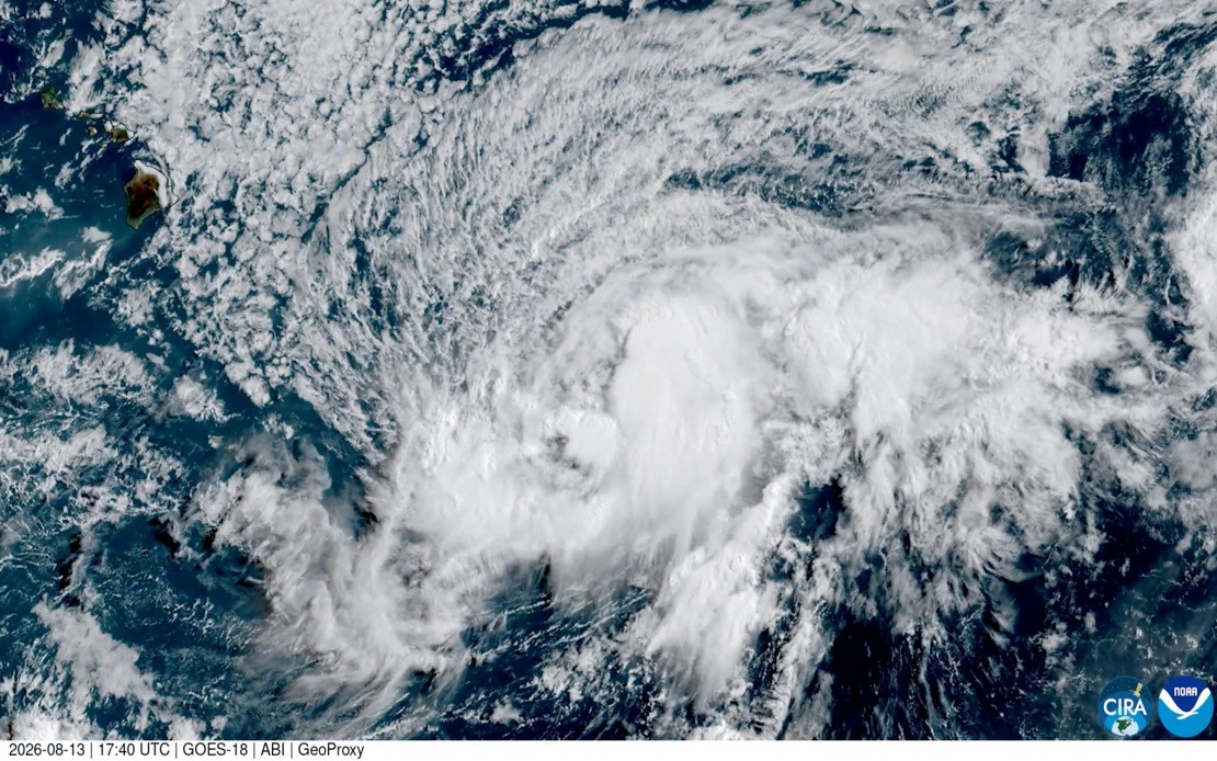
Tropical Storm Lala is gaining intensity as it tracks toward Hawaii's Big Island, with meteorological authorities expecting the system to achieve hurricane status before making landfall this coming Saturday. The National Hurricane Centre has issued formal warnings for the region, underscoring the seriousness of the approaching threat. Should the storm make direct contact with the Big Island, it would represent an extraordinarily rare weather event—the island has not experienced a hurricane landfall in over 150 years, a span that encompasses the entire modern era of satellite meteorology.
The last recorded hurricane to strike the Big Island dates back to 1871, a Category 3 system that impacted the northeastern portion of the island. This historical record, painstakingly reconstructed by atmospheric scientists at the University of Hawaii who reviewed archived newspaper accounts from that era, underscores just how infrequent such occurrences are in Hawaii's meteorological history. The gap of more than a century and a half between landfalls means that most residents alive today have no direct experience with such an event.
Vanessa Almanza, a meteorologist with the National Weather Service in Honolulu, emphasised the exceptional nature of the current forecast. She noted that within the satellite era—roughly the last six decades during which precise storm tracking became possible—Hawaii's Big Island has remained remarkably free from direct hurricane impacts. The latest computer models show Lala positioning itself perilously close to the island's southern tip, a trajectory that raises serious concerns among emergency management officials and weather professionals throughout the Hawaiian Islands.
The dual threats posed by Tropical Storm Lala extend beyond the immediate wind hazard typically associated with hurricanes. Heavy rainfall accompanying the storm system threatens to trigger destructive flooding across vulnerable areas of the Big Island, potentially affecting both populated zones and rural terrain. The intense precipitation could overwhelm drainage systems and trigger mudslides in steep volcanic terrain, compounding the disaster risks facing communities in the storm's path.
Equally concerning is the fire danger that strong hurricane winds would create across the Big Island's landscape. The combination of powerful gusts and the island's frequently dry conditions during summer months creates an environment where wildfires can spread with alarming speed. Wind-driven flames could consume vast areas of vegetation and threaten populated areas, particularly in regions where homes are interspersed with grasslands and forest cover. This compound hazard—simultaneous threats of flooding and wildfire—represents an unusually complex disaster scenario for emergency responders.
Official warning systems have been activated across the Hawaiian Islands to communicate the approaching danger to residents and visitors. A hurricane warning specifically targets the Big Island, reflecting the highest level of confidence in significant impacts from Lala. Meanwhile, a tropical storm warning extends to Maui County, encompassing the islands of Maui, Molokai, Lanai and Kahoolawe, indicating that these areas face substantial wind and water hazards even if hurricane-force conditions do not materialize there.
The potential for such a rare event carries broader implications for Hawaii's preparedness infrastructure and emergency management systems. Many communities across the islands have developed procedures and contingency plans based on theoretical scenarios rather than recent practical experience. The last generation to experience a direct hurricane impact on the Big Island is now elderly or deceased, meaning institutional knowledge about response and recovery operations has largely faded. Current officials and emergency management personnel are drawing extensively from historical records and training scenarios as they activate response protocols.
From a Southeast Asian perspective, Tropical Storm Lala's intensification and potential impact on Hawaii illustrates the dynamic nature of Pacific Basin weather systems and the broader climate patterns that influence the entire tropical region. The warming ocean temperatures that fuel such systems affect atmospheric circulation patterns across a vast area extending from the western United States through Hawaii and into the western Pacific rim where Southeast Asian nations are located. Understanding the mechanisms driving tropical cyclone development in these regions provides valuable context for regional weather prediction and climate science.
The convergence of multiple hazards—hurricanes, flooding, and wildfire—in a single weather event demonstrates the complexity of modern disaster management in island communities. Hawaii's response to Tropical Storm Lala offers lessons applicable to other vulnerable regions, including Southeast Asian nations frequently threatened by typhoons and tropical cyclones. The importance of maintaining detailed historical records, conducting regular emergency preparedness drills, and updating infrastructure standards in light of evolving weather threats resonates across the broader Asia-Pacific region where similar vulnerabilities exist.
As residents and officials throughout the Hawaiian Islands prepare for Lala's approach, the forecast represents a humbling reminder of nature's power and the unpredictability inherent in atmospheric systems. Whether the storm ultimately achieves hurricane strength and strikes the Big Island as predicted will become clear within the coming days, but the alert status already imposed across the islands reflects the serious possibilities that meteorological science has identified.

