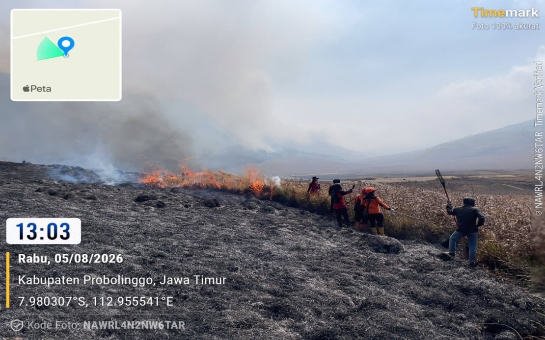
A significant wildfire threatening one of Indonesia's most iconic volcanic landscapes has forced authorities to deploy sophisticated aerial firefighting capabilities across East Java. The blaze at Mount Bromo, which ignited on Monday, has charred roughly 60 hectares split between Probolinggo Regency and the Bromo Tengger Semeru National Park in Malang Regency, prompting the National Disaster Management Agency (BNPB) to commit two water-bombing helicopters to the containment effort.
The distribution of burned terrain underscores the fire's reach across multiple jurisdictions and terrain types. Abdul Muhari, head of BNPB's Disaster Data, Information and Communication Centre, detailed that approximately 10 hectares have been consumed in Probolinggo Regency, while the remaining 50 hectares lie within the protected national park area. This division of the affected zone has complicated response coordination, requiring cooperation between local government authorities and national park management to ensure comprehensive coverage.
The deployment of aerial assets reflects the challenging topography of Mount Bromo's slopes, where conventional ground-based firefighting reaches its practical limits. The helicopter intervention specifically targets hotspots located on steep inclines that emergency personnel cannot safely or efficiently access from the ground. This tactical approach acknowledges that while ground teams have achieved significant progress, the most persistent fire concentrations remain stubbornly entrenched in geographically inaccessible zones where terrain itself becomes an obstacle to extinguishment efforts.
By Thursday, when officials announced the aerial deployment, most of the visible flames had been subdued following intensive ground operations on Wednesday afternoon. However, the persistence of smoldering hotspots in remote locations suggested that fire suppression would extend beyond the initial crisis phase. The joint emergency response team, comprising personnel from multiple agencies and local authorities, maintained continuous surveillance and targeted suppression activities despite the difficult conditions presented by Mount Bromo's volcanic landscape.
Beyond immediate helicopter operations, Indonesian disaster management authorities are exploring advanced meteorological intervention as a supplementary containment strategy. The BNPB is preparing to execute a Weather Modification Operation contingent upon favorable atmospheric conditions. This technique, which involves cloud seeding and other precipitation-enhancement methods, could theoretically increase moisture in the air column above the fire zone, reducing fire intensity and aiding the suppression efforts already underway on the ground.
The temporary closure of sections of Mount Bromo's tourist area represents a significant decision balancing public access with operational necessity and visitor safety. The Bromo Tengger Semeru National Park Authority has maintained restricted access until conditions permit safe reopening, a measure that protects both firefighting personnel and potential visitors from smoke inhalation, ash exposure, and unexpected fire behavior. The decision also creates operational space for emergency crews to maneuver without managing civilian movement in a hazardous environment.
Initial investigation has suggested that the fire originated from an abandoned campfire left by hikers, a finding that reflects ongoing challenges in managing human activity within protected natural areas across Southeast Asia. However, authorities have emphasized that the investigation remains preliminary and the confirmed cause continues under review. This preliminary assessment raises questions about visitor education and enforcement mechanisms within the national park system.
The Mount Bromo incident carries broader implications for Indonesia's disaster response infrastructure and inter-agency coordination mechanisms. The coordinated deployment of helicopters, ground teams, and potential weather modification resources demonstrates the multi-layered approach that major fire events now demand. For Malaysia and other Southeast Asian nations with comparable volcanic and forested landscapes, the Indonesian response offers a case study in resource allocation and cross-jurisdictional emergency management.
The timing of the wildfire during the dry season highlights the seasonal vulnerability of Indonesia's natural areas to fire events. Mount Bromo and surrounding regions face predictable fire risk windows annually, yet each major incident tests the preparedness and response capacity of both local authorities and national disaster management frameworks. The successful mobilization of specialized assets in this case reflects institutional learning from previous large-scale fire events across Indonesia.
From a regional perspective, the Mount Bromo fires underscore the importance of fire prevention education and visitor management in protected areas. With tourism recovery accelerating across Southeast Asia, parks and natural sites face renewed pressure from increased foot traffic. The potential connection between recreational activities and fire ignition demands renewed attention to visitor protocols and enforcement capabilities.
The convergence of multiple response tools—ground suppression, aerial water-bombing, weather modification planning, and inter-agency coordination—characterizes contemporary wildfire management in developing Southeast Asian contexts. While the Mount Bromo operation ultimately succeeds or fails based on ground-level execution, the deployment strategy reflects a recognition that natural disasters of this scale require comprehensive, technologically diverse responses rather than single-approach solutions.

