Japan's meteorological authorities issued urgent warnings on Friday as two separate typhoons converged on the nation, threatening to batter the country with torrential rain and destructive winds through the weekend. The Japan Meteorological Agency cautioned that Typhoon Higos would advance from the Pacific and strike land within hours, while simultaneously monitoring the trajectory of Typhoon Mekkhala, which had already begun affecting southwestern regions. The dual-typhoon scenario presented an exceptionally challenging weather emergency for crisis management officials tasked with protecting millions of residents across vulnerable districts.
The scale of the evacuation operation underscored the severity of the threat. By Friday morning at 7 am local time, the Fire and Disaster Management Agency had ordered over 2 million people to leave their homes across 13 prefectures spanning the Kinki and Kyushu regions. This represented a massive logistical undertaking for local governments, requiring coordination of shelters, emergency services, and transportation networks across multiple jurisdictions. The breadth of the evacuation orders reflected the meteorological agency's assessment that both storms posed serious risks across a geographically extensive area rather than affecting isolated localities.
Rainfalls preceding the typhoons' expected landfall had already begun to accumulate to dangerous levels. Between Tuesday and Friday morning, the city of Goto in Nagasaki Prefecture recorded 600 millimetres of precipitation, while inland areas experienced similarly intense downpours. Aso in Kumamoto Prefecture and Ureshino in Saga Prefecture each received more than 500 millimetres during the same period, saturating the ground and increasing vulnerability to secondary disasters. These rainfall totals, spread over several days, had already triggered the first emergency response in Seika, Kyoto Prefecture, where authorities issued the highest-level 5 emergency alert for portions of the town following a landslide that struck in the early morning hours.
Meteorologists emphasized that the approaching typhoons would likely bring even more substantial precipitation once they made landfall. The Tokai region faced projections of up to 300 millimetres of additional rain by Saturday noon, while the Kanto-Koshin region was forecast to receive up to 150 millimetres. These figures represented cumulative rainfall that would compound the saturation already present in the soil, dramatically elevating the risk of slope failures, flooding in low-lying areas, and infrastructure damage. The Japan Meteorological Agency warned specifically of strong storms developing across Okinawa Prefecture and eastern Japan as Typhoon Higos moved northward along the country's southern flank.
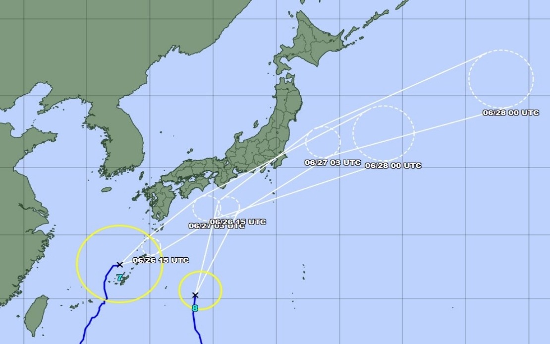
Typhoon Mekkhala's position and movement pattern posed particular complications for forecasters and emergency planners. As of Friday morning at 11 am, the typhoon was located off the coast of Kume Island in Okinawa Prefecture, tracking northeast at 15 kilometres an hour. This trajectory suggested it would eventually pivot toward the Kanto region, potentially creating a scenario where both typhoons influenced weather patterns across eastern Japan simultaneously. The convergence of two storm systems in the same general area raised concerns about rainfall rates that could exceed historical norms and challenge response capacity.
While meteorological models predicted that both typhoons would weaken as they transitioned into extratropical cyclones upon approach to or after landfall, the agencies cautioned against complacency. Extratropical cyclones can remain dangerous systems capable of producing significant precipitation and strong winds, particularly when multiple systems influence the same region. The Japan Meteorological Agency specifically urged the public to maintain heightened vigilance regarding landslide hazards and flood risks that could persist even after the systems weakened structurally.
For Malaysian and Southeast Asian observers, Japan's typhoon response illustrates the magnitude of tropical cyclone threats affecting the western Pacific region. While Malaysia itself lies south of the primary typhoon belt, understanding how advanced weather agencies and densely populated nations manage these disasters provides valuable perspective on regional storm vulnerability. Japan's rapid evacuation procedures and sophisticated forecasting demonstrate both the necessity and feasibility of comprehensive early warning systems when populations face significant natural hazards.
The economic and social disruptions flowing from such weather events extend beyond the immediate disaster period. Evacuations disrupt commerce, education, and healthcare services. Infrastructure damage from flooding and landslides imposes substantial reconstruction costs and creates cascading effects through supply chains. For Southeast Asia, Japan's experience underscores the importance of investing in meteorological infrastructure, establishing clear evacuation protocols, and maintaining public awareness regarding severe weather threats, particularly as climate patterns continue evolving.
The simultaneous approach of two typhoons also presented challenges for resource allocation across the Japanese government. Emergency services, rescue teams, and support personnel would need to distribute themselves across multiple regions simultaneously, potentially stretching capacities. Coordination between the national meteorological agency, local governments, and disaster management authorities became crucial to ensuring that the most vulnerable areas received adequate attention and that evacuation instructions reached the public clearly and timeously. Communication clarity proved particularly important given the scale and complexity of the weather threat.