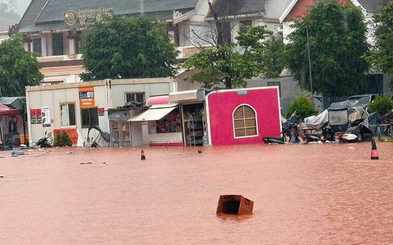
Luang Namtha province in northern Laos was officially designated a disaster zone on Saturday, August 29, following severe flash flooding that devastated communities around the strategic Laos-China border crossing at Boten. The cascading waters inundated more than 30 villages across the province, destroying or partially submerging buildings, farmland, schools, hospitals and other essential infrastructure in what authorities are treating as a major humanitarian emergency requiring coordinated disaster response.
The Luang Namtha Provincial Administrative Committee issued the formal declaration after rapid-onset flooding and associated landslides swept through Luang Namtha and Nalae districts. The deluge hit communities without warning as upstream river systems swelled dramatically in response to sustained heavy rainfall over preceding days. Water levels rose swiftly and unexpectedly, catching residents and local administrators off guard despite some advance weather forecasting. The extent of the inundation became apparent only as water reached previously dry areas, overwhelming weak embankments and drainage systems designed for smaller flood events.
While the border crossing infrastructure at Boten itself escaped direct damage, nearby settlements, commercial zones and agricultural land bore the brunt of the floodwaters. A special economic zone in the vicinity sustained significant damage, with business operations disrupted and facilities compromised. Airports in the affected region experienced disruptions, and educational and healthcare facilities fell into partly flooded conditions, hampering both service delivery and emergency response coordination during the critical initial hours.
The underlying cause traces to rapidly rising water levels in upstream tributaries, particularly the Tha River system. Hydrology data from Saturday showed the Tha River reaching 6.58 metres—exceeding the standard 6-metre flood warning threshold and approaching the critical 7-metre marker that signals severe inundation conditions. This measurement provided hard evidence of hydrological stress that officials could quantify when issuing emergency directives. The Department of Meteorology and Hydrology, operating under the Ministry of Agriculture and Environment, extended formal flood warnings for the Tha River covering August 29 and 30, anticipating that water levels might climb further.
Responding to the escalating situation, provincial administrators issued mandatory alert orders to five districts, instructing local government structures to inform residents in riverside communities, topographical depressions and other vulnerable zones about potential evacuation requirements. These precautionary measures reflected concern that water levels could rise beyond current peaks if rainfall intensified. Officials at district and village levels received instructions to maintain continuous vigilance, execute swift incident response protocols and maintain regular reporting channels to provincial command centres. The intent was to establish a reactive chain capable of moving residents to safety before flood waters made roads impassable or rendered evacuation too dangerous.
The flooding event occurred within a broader meteorological context affecting much of mainland Southeast Asia. A low-pressure weather system positioned over northern Laos and extending into adjacent southwest China was generating atmospheric instability. This system, functioning in tandem with the south-westerly monsoon circulation pattern characteristic of late August, created conditions favouring persistent precipitation. Meteorologists expected the combination to produce scattered but potentially intense thunderstorms, moderate to heavy rainfall bands and strong gusty winds—conditions that would exacerbate hydrological stress in already-saturated watersheds.
The geographic scope of elevated flood risk encompassed fourteen provinces across Laos, indicating this was not merely a localised incident but rather a systemic weather pattern affecting large regions. The at-risk provinces stretched from Phongsaly and Huaphan in the far north through central areas including Luang Prabang, Oudomxay, Xaysomboun, Bolikhamxay and Khammuan, extending southeastward through Savannakhet, Salavan, Xekong and Champasak, and reaching the capital region of Vientiane itself. This exceptionally wide footprint meant emergency management authorities had to coordinate resources and information across multiple jurisdictions simultaneously.
For Malaysian observers and policymakers, the Laos flooding episode carries several instructive implications. Southeast Asia's monsoonal climate creates recurring and sometimes severe precipitation events that demand robust early warning systems and inter-provincial coordination mechanisms. The incident underscores how border regions—often geographically remote and infrastructure-poor—face disproportionate vulnerability when natural disasters strike. Cross-border water management becomes critical when floods originating in Chinese territory sweep southward through Laos, a relationship that may parallel challenges in Malaysian river systems where transboundary water issues occasionally surface.
The disaster also highlights the capacity limitations facing smaller Southeast Asian nations when confronting large-scale environmental emergencies. Laos's relatively sparse technical resources for real-time hydrology monitoring and early warning dissemination mean that response windows remain compressed, leaving insufficient time for complex evacuation operations. The emphasis on local officials maintaining alertness and preparing residents suggests a decentralised response model relying on community-level action rather than centralised state machinery—a structure common across the region but which depends heavily on effective information flow and grassroots preparedness.
Officially issued public warnings instructed residents along river corridors and in depression-prone lowlands to remain attentive to weather information, monitor official advisories closely and prepare psychologically and materially for potential flash floods and associated landslide hazards. The framing of these warnings, which combined practical preparedness messaging with the reality that evacuation might become necessary, reflected official acknowledgement that some populated areas faced genuine peril. However, the warnings also demonstrated how meteorological information, when translated into accessible public guidance, can empower communities to take protective action even when government resources remain limited.

