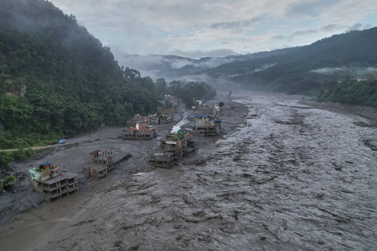
Nepal's deadliest recent natural disaster has laid bare a troubling reality: residents in vulnerable Himalayan valleys received virtually no advance notice before floodwaters engulfed their communities. The catastrophe, triggered by a glacial collapse on August 26, swept away entire settlements with devastating speed, yet according to Dharam Raj Uprety, chief executive of Nepal's National Disaster Risk Reduction and Management Authority, affected populations had fewer than five minutes of warning before the deluge arrived. This shocking absence of lead time points to systemic failures in the region's approach to climate monitoring and international cooperation on disaster prevention.
The underlying problem is starkly simple: Nepal lacks adequate weather monitoring infrastructure across its high mountain terrain. Speaking to Bloomberg News, Uprety identified the shortage of high-altitude weather stations as a primary constraint, explaining that this absence stems from poorly developed mechanisms for sharing weather and climate information across international boundaries. The absence of "trans-boundary data seeding," as he termed it, represents one of the authority's most formidable obstacles. When weather stations cannot be positioned in remote mountain areas—a task both financially prohibitive and technically challenging—authorities operate with a dangerously incomplete picture of developing hazards, leaving communities defenceless against rapidly changing mountain conditions.
The scale of the devastation underscores the human cost of this monitoring gap. The floods and associated landslides have claimed at least 800 lives, with more than 3,000 people unaccounted for. The disaster's economic impact will prove equally severe, with damage estimates reaching at least US$5 billion according to Binod Chaudhary, Nepal's only billionaire. Reconstruction is anticipated to stretch across seven to eight years, mirroring the lengthy recovery period that followed the 2015 earthquake. Beyond the immediate human tragedy, the disruption threatens the tourism sector, which generates crucial employment and foreign currency for an economy heavily dependent on the attractions of the Himalayan region.
Climate scientists have identified the triggering mechanism: satellite analysis suggests that bedrock beneath a glacier destabilised, initiating a cascading chain reaction of ice, mud, water and rock that tore through a valley with overwhelming force. Eyewitness videos captured the horrifying reality—people desperately attempting escape as walls of debris-laden water swallowed buildings, demolished bridges and power infrastructure, and swept away trees, boulders and vehicles. While researchers caution that attributing this specific event directly to anthropogenic climate change remains premature, the underlying risk factors are increasingly clear. Rising temperatures destabilise glaciers and weaken permafrost that normally binds high-altitude terrain together, creating conditions in which such failures become progressively more likely.
The challenge facing Nepal extends well beyond its borders. The Himalayan mountain system functions as a unified hydrological and climatic zone, with weather patterns and glacial conditions developing across the broader Tibetan Plateau region that encompasses significant portions of Chinese territory. This geographic reality has prompted Xi Jinping to call for accelerated glacier surveys and glacial lake monitoring across the plateau, with China's Communist Party subsequently ordering enhanced monitoring and early-warning systems to better identify interconnected disaster risks. Nevertheless, the question of effective data sharing between Nepal and China remains contentious and inadequately resolved.
China's official response has been characteristically cautious. The Chinese Embassy in Nepal issued a statement asserting that China "has always made every effort, within the limits of existing technologies, to conduct monitoring, assessment and analysis and have shared important information with the Nepali side in a timely manner." The statement emphasised that the two nations have maintained "close communication on transboundary disaster management," yet conspicuously avoided confirming whether China had specifically alerted Nepal to developing dangers in the days preceding the August 26 catastrophe. This ambiguity reflects the broader tension in bilateral relations and the limited transparency that currently characterises cross-border environmental data exchange.
Uprety has articulated a crucial insight: the fundamental problem cannot be solved through technology alone. Nepal possesses monitoring capabilities in areas farther downstream from the disaster zone, yet large expanses of high mountain terrain remain poorly observed. The practical obstacles are substantial—installing and maintaining weather stations at extreme altitude demands substantial financial resources and extraordinary logistical effort. Cold temperatures, harsh weather, difficult access, and the need for constant maintenance create conditions where observation stations become expensive luxuries rather than standard infrastructure. Without adequate funding and technical capacity, authorities remain unable to detect rapidly shifting temperature patterns, changing permafrost conditions, or emerging glacial hazards until catastrophe has already begun.
Recognising that the status quo is untenable, Nepal's disaster management authority has drafted a strategic roadmap designed to strengthen early-warning systems across the nation. The approach prioritises extending advance notice to communities, thereby providing essential preparation time before disaster strikes. This represents a marked shift toward understanding disaster management not merely as post-event response but as anticipatory action grounded in improved intelligence. However, implementation of such improvements requires substantial financial investment and sustained political commitment—resources that must be mobilised at precisely the moment when Nepal is already stretched thin managing the immediate humanitarian crisis and planning reconstruction efforts.
The Nepal floods illuminate a broader Southeast Asian vulnerability. Mountain communities across the region—in Thailand, Laos, Myanmar, and beyond—face comparable risks from glacial collapse, glacial lake outburst floods, and rapidly changing mountain hydrology driven by climate change. Few nations in the region have invested adequately in high-altitude monitoring infrastructure, and transboundary data sharing remains fragmented at best. The Mekong River basin's vulnerability to upstream hydrological changes underscores how disaster risks transcend national boundaries. Nepal's tragedy should serve as an urgent signal that the region requires coordinated investment in mountain monitoring systems and binding agreements for real-time hazard data exchange.
Uprety's final observation captures the essential challenge: "Unless we stop making boundary for climate information," disasters originating in remote mountain areas will remain exceptionally difficult to foresee and therefore impossible to prevent. This statement reflects a fundamental tension between national sovereignty and the transnational reality of climate systems and mountain hazards. Governments naturally guard scientific data as strategic assets, yet the human cost of such information compartmentalisation may ultimately prove indefensible. The Nepal disaster suggests that the region's governments must reconsider traditional approaches to data sharing and embrace collaborative frameworks that prioritise early warning over competitive advantage, recognising that in an era of accelerating climate change, transparency and cooperation in mountain monitoring may prove as essential to survival as the monitoring systems themselves.

