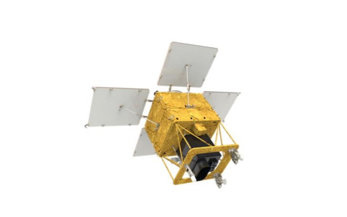
South Korea has successfully deployed its fourth homegrown medium-sized Earth observation satellite, marking a significant milestone in the nation's growing space ambitions. The 500-kilogramme satellite lifted off from Vandenberg Space Force Base in California aboard a SpaceX Falcon 9 rocket, representing a strategic shift towards operational independence in satellite-based intelligence gathering and environmental monitoring across the Korean Peninsula and beyond.
The launch, coordinated by the Korea AeroSpace Administration (KASA), demonstrates Seoul's commitment to developing indigenous space capabilities that reduce reliance on foreign operators for critical Earth observation data. This multi-satellite constellation approach mirrors strategies adopted by other technologically advanced nations seeking strategic autonomy in space-based reconnaissance and civilian monitoring applications. The timing of this deployment underscores the growing importance of satellite imagery in regional geopolitics, particularly as tensions on the Korean Peninsula remain elevated and environmental challenges demand continuous surveillance.
The satellite's design incorporates cutting-edge homegrown payloads, most notably an advanced observation camera system capable of capturing detailed images of the entire Korean Peninsula once every three days. This imaging frequency provides sufficient temporal resolution for meaningful monitoring of large-scale environmental changes, seasonal variations, and land-use transformations. The domestic development of these critical sensors reflects years of research investment and technical collaboration between South Korean aerospace institutions, reducing future mission costs and strengthening domestic technological capacity.
Following its separation from the Falcon 9 approximately two hours and twenty-two minutes after liftoff, the satellite will establish initial contact with receiving stations through the Svalbard ground facility in Norway, a strategically important Arctic location for polar-orbiting satellite communications. This northern tracking station provides reliable data relay capabilities for high-latitude orbits, essential for maintaining continuous contact with satellites deployed in sun-synchronous trajectories. The successful handoff to ground control networks represents a critical validation point in the mission timeline.
The satellite will eventually settle into an operational orbit at approximately 888 kilometres altitude, a standard height for Earth observation platforms that balances imaging resolution with orbital longevity and fuel efficiency. From this vantage point, the satellite will provide comprehensive coverage of diverse applications ranging from agricultural productivity assessment to forest management and coastal zone monitoring. The altitude selection reflects sophisticated mission planning that optimises the trade-offs between ground resolution, area coverage, and mission duration.
South Korea's expanding vision for satellite applications extends well beyond simple image collection. Government planners envision utilising the constellation for sophisticated disaster response coordination, enabling rapid damage assessment following typhoons, floods, or other natural catastrophes that frequently impact East and Southeast Asia. The satellite's capabilities will support climate change analysis through multi-temporal observation of glaciers, sea ice, vegetation patterns, and ocean conditions, contributing to long-term environmental research initiatives. Additionally, improved public safety applications ranging from urban planning to infrastructure monitoring will benefit from consistent, high-quality satellite data.
The initial four-month in-orbit testing phase following orbital insertion represents a comprehensive validation period where KASA engineers will verify all systems, calibrate instruments, and confirm that performance meets design specifications. This deliberate approach to commissioning prevents premature deployment of systems with undiagnosed faults or calibration errors. Only after successful completion of these rigorous test phases will the satellite transition to full operational status in the first half of next year, joining the growing constellation of Korean observational assets.
The implications for Southeast Asia extend beyond South Korea's immediate borders. As the region becomes increasingly integrated into global supply chains and faces mounting environmental pressures, access to high-frequency, high-resolution satellite imagery becomes strategically valuable. Malaysian agricultural planning, forest conservation efforts, and disaster preparedness initiatives could potentially benefit from partnership arrangements or data-sharing agreements with South Korean space agencies, particularly as regional nations develop coordinated approaches to transboundary environmental monitoring and climate adaptation.
This launch exemplifies the broader trend of mid-sized regional powers developing indigenous space capabilities to address specific national priorities. Unlike the superpowers with massive satellite fleets, countries like South Korea pursue focused, purposeful satellite programmes aligned with concrete civilian and strategic applications. The approach offers lessons for other Southeast Asian nations considering space investments, demonstrating that technological sophistication and practical utility need not require massive budgets or duplicative competing systems. The reliance on established commercial launch providers like SpaceX, meanwhile, highlights how modern space powers leverage the emerging commercial space industry while maintaining control over payload development and data interpretation.