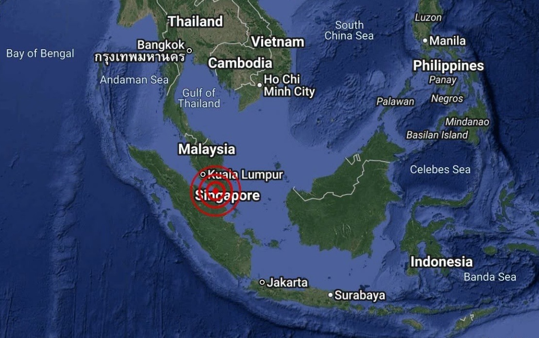
An earthquake with a magnitude of 3.1 rattled the waters off Batu Pahat in Johor state on August 25, marking another seismic event in Malaysia's established earthquake zone. The tremor was recorded at 4.12 pm local time, with the epicentre pinpointed at coordinates 1.7 degrees north and 102.8 degrees east, placing it roughly 18 kilometres southwest of Batu Pahat town itself. The Malaysian Meteorological Department, through its National Weather and Earthquake Operations Centre, promptly issued an assessment confirming that no tsunami threat existed for Malaysia or its surrounding waters.
The Batu Pahat waters have long been recognised as a seismically active region in Malaysia, situated along tectonic boundaries that periodically generate minor to moderate tremors. While earthquakes of this magnitude are relatively commonplace in the broader Southeast Asian context, their occurrence in populated or economically significant areas warrants immediate official monitoring and public communication. The rapid response from MetMalaysia underscores the importance of established protocols for earthquake detection and tsunami risk assessment, particularly given Malaysia's geographical proximity to the seismic zones of the Indian Ocean and the Sunda Strait region.
Under 4.0 on the Richter scale, tremors of this strength are generally classified as minor earthquakes that may be felt by people in close proximity to the epicentre but typically cause no structural damage or widespread disruption. The offshore location of this particular event would have limited the number of people directly experiencing the earthquake, though some residents in southern Johor may have reported subtle ground movement or vibration. For the broader Malaysian population, earthquakes of this magnitude rarely trigger emergency response measures beyond standard monitoring and information dissemination.
The absence of a tsunami warning reflects both the earthquake's moderate magnitude and its depth characteristics, which MetMalaysia's experts assess as posing no danger to coastal communities. Tsunamis are typically generated by larger, shallow-depth submarine earthquakes, particularly those exceeding magnitude 6.0. The systematic evaluation of potential tsunami risks forms a critical component of regional disaster management frameworks, especially given the Indian Ocean's history of catastrophic seismic and tsunami events. Malaysia's participation in the Indian Ocean Tsunami Warning System demonstrates the nation's commitment to early warning protocols that protect citizens and regional economies dependent on maritime activities.
Geologically, the Batu Pahat region sits within one of Malaysia's more active earthquake zones, a consequence of its proximity to underlying tectonic structures and fault lines. The Sunda Strait, located west of Peninsular Malaysia, remains another significant seismic zone, while eastern Sabah experiences occasional tremors related to the subduction zones of the Sulu Sea and Celebes Sea. Understanding Malaysia's seismic landscape proves essential for urban planning, infrastructure development, and disaster preparedness initiatives, particularly as population centres expand and critical infrastructure projects require heightened earthquake resilience standards.
The incident highlights the ongoing importance of maintaining robust earthquake monitoring networks across Malaysia, a responsibility coordinated primarily through MetMalaysia's seismic division. Real-time detection and rapid public communication of seismic events, no matter how minor, contribute to public confidence in government disaster management capabilities and help establish baselines for long-term seismic trend analysis. For Malaysian researchers, each recorded earthquake adds to the growing database of seismic activity that informs structural engineering standards, building codes, and hazard mapping exercises conducted by relevant authorities.
From a regional perspective, earthquakes in Malaysian waters form part of the broader seismic activity characterising the western Pacific and Southeast Asian tectonically active regions. Neighbouring Indonesia, situated atop the Pacific Ring of Fire, experiences significantly higher earthquake frequency and magnitude, yet Malaysia's occasional tremors remind policymakers and citizens alike of the need for continued vigilance. Educational initiatives promoting earthquake awareness and preparation, particularly in schools and communities, remain valuable investments in public safety and resilience.
For residents and businesses in Johor, particularly those operating in maritime industries or coastal development projects, routine earthquake monitoring and understanding of safety protocols form part of standard risk management. The August 25 tremor, though minor, serves as a reminder of natural hazards that exist beyond human control and underscores the value of preparation, early warning systems, and expert guidance from meteorological and geological institutions. MetMalaysia's confirmation of safety would have provided reassurance to anxious residents while demonstrating the transparency and competence expected from national disaster management authorities.
Moving forward, continued investment in seismic monitoring infrastructure, training of personnel, and public education regarding earthquake preparedness remains essential. As Malaysia develops economically and expands its marine industries, offshore infrastructure projects must incorporate earthquake engineering principles to ensure resilience against potential seismic events. The incident also highlights opportunities for regional cooperation in earthquake science and tsunami warning systems, fostering knowledge-sharing among Southeast Asian nations facing similar geological hazards and requiring coordinated response mechanisms.

