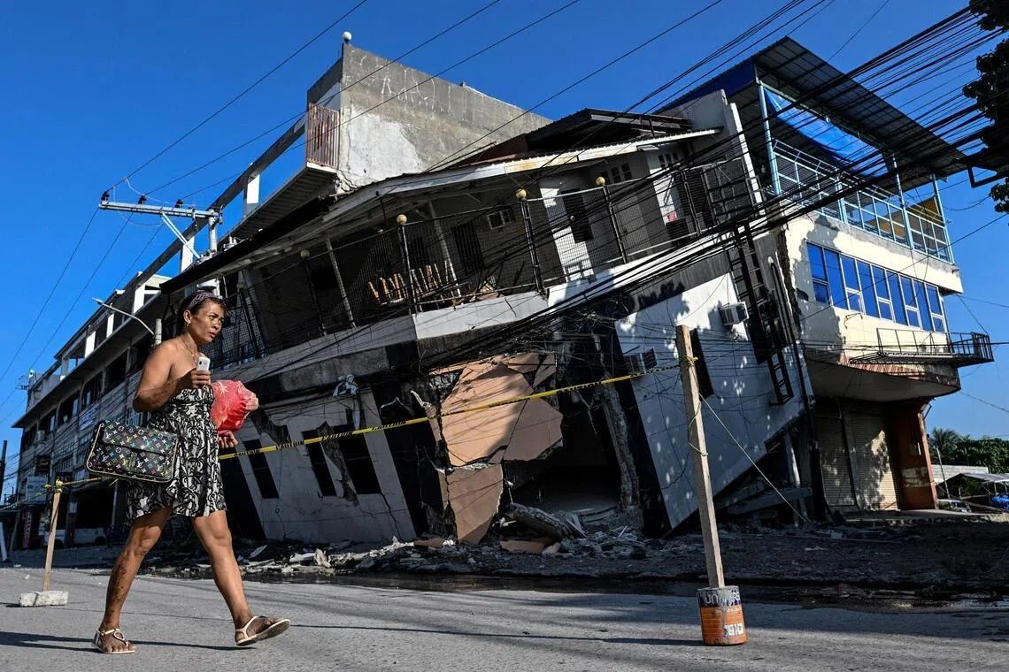
The moment the earth began to shake beneath his home in Glan, Sarangani province, Arsenio Butil Jr. dropped to his knees in prayer. When tremors from the June 8 earthquake finally subsided, the fisherman and pastor witnessed something extraordinary unfolding before his eyes: the familiar waterline of his coastal neighbourhood was vanishing, replaced by a landscape of once-submerged coral reef now exposed to the Philippine sun. The 7.8-magnitude quake, triggered by tectonic shifts along the nearby Cotabato Trench, had unleashed forces that would reshape not only the physical geography of southern Mindanao but also the lives of thousands who depend on these waters for survival.
The destructive power of the earthquake extended far beyond the visible transformation of the shoreline. Across the southern island of Mindanao, at least 76 people lost their lives as buildings crumbled and hillsides gave way to landslides. The seismic event represented one of the most powerful tremors to strike the region in living memory, leaving residents shaken and deeply fearful about what might come next. For many residents, the intensity of the quake was surpassed only by the surreal experience of watching their physical surroundings undergo dramatic, permanent change in real time.
The phenomenon responsible for the coastline transformation is known among geologists as "coastal uplift"—a process where tectonic forces push sections of the Earth's crust upward during an earthquake. In this instance, the displacement was substantial enough to be immediately visible and measurable. According to Nane Danlag, a specialist at the Philippines' seismology centre, the seabed rose approximately two metres across the affected region. This uplift extended the shore by as much as 200 metres in certain areas, creating new land where water once dominated. The transformed coastline stretched across a zone spanning nearly 100 kilometres between two towns, fundamentally altering the geography that residents had known their entire lives.
For those who make their living from the sea, the coastal uplift created an entirely new set of challenges. Fishing boats that had been moored at the water's edge now sat stranded on the wrong side of a jagged wall of dead coral, their access to the ocean abruptly severed. The sight of these vessels, rendered useless by geological transformation, symbolised the sudden displacement of an entire way of life. Butil Jr. described witnessing the water receding and returning multiple times during the earthquake—a phenomenon that horrified residents and sent clear signals of the oceanic upheaval occurring beneath the surface. Dead fish floated in the churning waters, further underscoring the ecological disruption caused by the seismic event.
The Cotabato Trench, positioned as close as 50 kilometres off the Mindanao coast, sits at the intersection of major tectonic plates and has long been recognised as a zone of intense seismic activity. Earlier this year, in January, seismologists recorded a swarm of thousands of small earthquakes in the area—a warning sign that caught the attention of international disaster risk reduction experts. A United Nations report released in mid-May suggested these tremors could potentially herald a major seismic event, though the precise timing remained impossible to predict. The June earthquake vindicated those concerns, arriving with devastating force and serving as a stark reminder of the region's geological volatility.
What transpired on June 8 is not an isolated anomaly but rather part of a continuous geological process that has been reshaping this coastline for millennia. Danlag emphasised that the coastal uplift represents a "natural movement" that has been occurring for thousands of years, driven by the relentless collision of tectonic plates. Understanding this context is crucial for residents and policymakers attempting to come to terms with the earthquake's aftermath. The forces at work are slow-acting over geological time but can unleash catastrophic consequences in seconds when stress along fault lines suddenly gives way.
Beyond the immediate loss of life and structural damage, the earthquake has created a psychological crisis among evacuated residents. Approximately 100 families, led by Maguindanaon chieftain Datu Atom Malimpnig, fled to higher ground when the quake struck and have remained encamped there ever since, supported by government aid workers distributing food. Many refuse to descend to their destroyed homes, gripped by fear that the transformed seabed could trigger a massive tsunami surge. The new coastline, with its exposed coral and changed configuration, has become a symbol of uncertainty rather than familiarity, fuelling anxiety about whether the worst might still lie ahead. For these families, the hill encampment feels considerably safer than returning to a landscape they no longer recognise or trust.
The economic implications of the coastal transformation extend to the broader tourism industry. Isla Jardin del Mar resort, once a destination marketed for its pristine white sand beaches and inviting ocean access, now faces a fundamentally altered customer proposition. Resort staff member Edzel Baylon lamented that the main attraction for visitors—the sea itself—has been compromised. Where visitors once enjoyed swimming in clear waters adjacent to the beach, they now encounter shallow, newly exposed seabed separated from the deeper ocean by an imposing barrier of jagged coral. The transformation threatens the economic viability of an enterprise built entirely on the appeal of the pre-earthquake coastline.
The aftermath of the June 8 earthquake has been marked by continued seismic unrest that compounds resident anxieties and complicates recovery efforts. According to the Philippines seismology agency, more than 8,500 aftershocks have rattled the region since the main event, ranging widely in magnitude and frequency. Each tremor serves as a reminder of the instability beneath the ground and the possibility that another powerful earthquake could strike without warning. Butil Jr. pointed to the extensive cracks visible in the ground as evidence that the area remains dangerously unstable and unsuitable for reconstruction efforts. The prospect of rebuilding homes in such conditions, only to see them destroyed again by a stronger aftershock, has deterred residents from attempting repairs.
Recovery efforts face daunting uncertainties that typical disaster response frameworks struggle to address. Unlike hurricanes or floods, which follow somewhat predictable patterns, earthquakes offer no warning and leave residents grappling with permanently altered geography and ongoing seismic uncertainty. Communities must simultaneously manage the immediate humanitarian crisis of homelessness and food insecurity while confronting the longer-term question of whether it is safe or prudent to rebuild in the affected areas. The coastal uplift, while geologically fascinating, represents a catastrophe for those whose livelihoods and homes depended on the old coastline. As the region continues to experience aftershocks—a 5.4 magnitude tremor shook the ground even as interviews were being conducted days after the initial quake—residents remain trapped in a state of enforced displacement, unable to move forward until seismic activity subsides and engineers can assess the structural integrity of the land.
For Malaysia and the broader Southeast Asian region, the Philippine earthquake serves as a sobering reminder of the seismic risks that characterise much of the western Pacific region. While Malaysia's exposure to major earthquakes is considerably lower than that of the Philippines or Indonesia, the region nonetheless sits in a tectonically active zone. The Philippine disaster underscores the importance of robust early warning systems, earthquake-resistant building codes, and comprehensive disaster preparedness planning. It also highlights the cascading economic and social consequences that extend far beyond immediate casualty figures, affecting tourism, fishing industries, and coastal communities across multiple sectors. As Southeast Asia continues to develop economically, with growing populations in coastal zones, the lessons from Mindanao's transformation demand serious consideration from policymakers across the region concerned with building resilience in the face of natural hazards.
%22%2F%3E%3C%2Fpattern%3E%3C%2Fdefs%3E%3Crect%20width%3D%22100%25%22%20height%3D%22100%25%22%20fill%3D%22url(%23ph50hvcg)%22%2F%3E%3Crect%20width%3D%22100%25%22%20height%3D%22100%25%22%20fill%3D%22url(%23ph50hvcp)%22%2F%3E%3Ctext%20x%3D%2250%25%22%20y%3D%2250%25%22%20text-anchor%3D%22middle%22%20dominant-baseline%3D%22central%22%20fill%3D%22rgba(255%2C255%2C255%2C0.95)%22%20font-family%3D%22Georgia%2C%20'Times%20New%20Roman'%2C%20serif%22%20font-weight%3D%22700%22%20font-size%3D%22170%22%20letter-spacing%3D%22-0.02em%22%3EMinistry%3C%2Ftext%3E%3C%2Fsvg%3E)